Global Aerial Imaging Market Size, By Platform (Fixed-wing Aircraft, Helicopter, UAV/drone), By Imaging Type (Vertical Imaging, Oblique Imaging), By Application (Geospatial Mapping, Disaster Management, Energy & Resource Management, Surveillance & Monitoring, Urban Planning, Conservation & Research), By End Use (Government, Energy, Military & Defense, Agriculture & Forestry, Archaeology & Civil Engineering, Oil & Gas) Regional Analysis (North America - U.S, Canada, Other) (Asia-Pacific -India, Japan, China, Australia, Other) (Europe – UK, Russia, France, Brazil, Other) (Middle East and Africa) - Global Industry Insights, Trends and Forecast, 2017-2025
Report Format : PDF
Published Date : Oct-2018
Pages : 190
Report ID : VSR00297
Report Format: PDF
Published Date: Oct-2018 | 190 Pages | Report ID: VSR00297
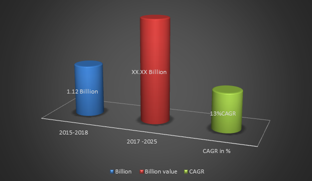
Global Aerial Imaging Market Size was valued nearly USD 1.12 billion by 2017 and is estimated to reach up to USD xx.xx billion by 2025. According to latest study conducted by our analysts and industry experts, the global market is expected to grow at a CAGR of 13.01% during the forecast period, i.e. 2017-2025 growth driven by end user such as government, energy, military & defense, agriculture & forestry, archaeology & civil engineering, and oil & gas etc. On the other hand the leading companies such as EagleView Technologies Inc., Google Inc., Nearmap Ltd., NRC Group ASA, and Fugro N.V. and other are actively engaged in bringing technological advancement in services.
Global Market Growth Opportunities (Revenue, Growth) By 2017-2025
This global market study report analysis offers in-depth insights, revenue details, and other vital information regarding the global aerial imaging market, and the various trends, drivers, restraints, opportunities, and threats in the target market till 2025. The report offers insightful and detailed information regarding the various key players operating in the market, their financials, supply chain trends, technological innovations, key developments, apart from future strategies, acquisitions & mergers, and market footprint. The global aerial imaging market report has been segmented on the basis of type, application, and region. It includes the estimation of the market size, in terms of value, with respect to 4 main geographies, namely, North America, Europe, APAC, and RoW. The major key players contribute significant growth over the forecast period. The report emphasis details about leading companies market share, size and future investment and forecast year’s strategies.
Market Dynamic
“Global Aerial Imaging Market showed crucial growth in the recent years and is anticipated to witness a steep rise by generating an estimated revenue of US$ xx.xx over the forecast period. According to latest study conducted by our analysts and industry experts, the global market is expected to grow at a CAGR of 13.1% during the forecast period, i.e. 2017-2025.”
The worldwide aerial imaging market is divided based on platforms, imaging type, application, end-user and regional analysis. On the basis of type, the aerial imaging market is segmented into platforms that are fixed-wing aircraft, helicopter, UAV/drone. The imaging type has been classified into vertical imaging, oblique imaging. The application segment is projected to health growth over the forecast timespan; the application segment has been divided into geospatial mapping, disaster management, energy & resource management, surveillance & monitoring, urban planning, conservation & research. The market is growing demand form end-user sectors such as government, energy, military & defense, agriculture & forestry, archaeology & civil engineering, and oil & gas. The global aerial imaging market is divided into regions that are North America - U.S, Canada, Other; Asia-Pacific -India, Japan, China, Australia, Other; Europe – UK, Russia, France, Brazil, Other; Middle East and Africa.
Segment Analysis
Platform Insights: Based on the application, the aerial imaging market is divided into fixed-wing aircraft, helicopter, UAV/drone. The UAV/drone segment is projected to hold the maximum industry share in coming years. Owing to huge demand from government and defense sectors because of this platform used for capturing aerial photographs in urban areas and government agencies used for law enforcement and crime investigation purposes.
Imaging Type Insights: The global aerial imaging market is segmented on the basis of imaging types that are vertical imaging and oblique imaging. The disaster management segment was valued significant growth in 2017 and is projected to continue show healthy growth over the forecast years, in terms of revenue owing to increasing use in oblique imagery in assessing building heights during the realistic texturing of 3D city models. The disaster management segment is anticipated to show an accelerated growth in the aerial imaging market during the forecast years and is projected to contribute measurable share by 2024 owing to increasing demand form government and defense sectors.
End User Insights: Based on the application, the aerial imaging market is segmented into end user that are government, energy, military & defense, agriculture & forestry, archaeology & civil engineering, and oil & gas. The agriculture market is excepted to witness a fastest growth in the coming years owing to growing demand from end-user because of technological advancements in drone platforms and sensor technologies which is helping to agriculture sector for assisting precision agriculture functions through the mapping of different parameters such as vegetation health, soil health, and fertility levels.
Regional Analysis
The global aerial imaging market is divided into regions that are North America - U.S, Canada, Other; Asia-Pacific -India, Japan, China, Australia, Other; Europe – UK, Russia, France, Brazil, Other; Middle East and Africa. Every region analysis details in sense of growth, revenue, volume, challenges, and opportunities with the regional and global key players. In 2017, North America market was held largest market share a cross globe and is anticipated to grow fastest during the forecast period owing to increasing demand from end user industries such as government, energy, military & defense, agriculture & forestry, archaeology & civil engineering, and oil & gas followed by Europe.
Global Aerial Imaging Market Size, Share Analysis By Region 2017
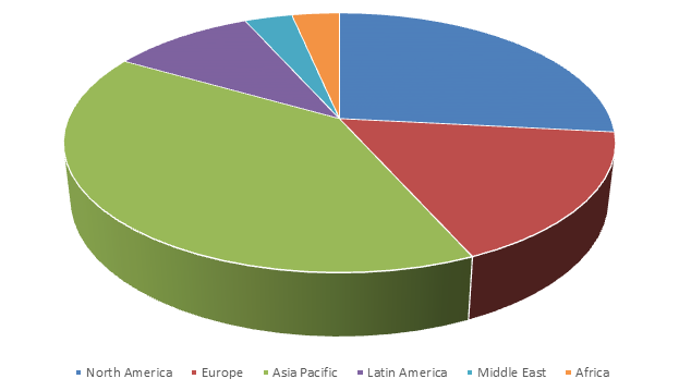
Asia Pacific aerial imaging market is estimated to witness the highest growth over the forecast period that is 2019 to 2025 owing to increasing awareness reading the utility of aerial imaging among developing countries India, China, Thailand, Japan, South Korea, Indonesia, Australia and Other countries, because of support to government law enforcement and crime investigation as well as it is helping to military and defense sectors for secure borders and internal threats is expected to register an accelerated growth in the region between 2018 and 2024.
Key Players
The major kay players in the aerial imaging market which will contribute healthy growth in regional and global market over the forecast period that key players are NRC Group ASA, Fugro N.V., Digital Aerial Solutions LLC, Nearmap Ltd., Google Inc., EagleView Technologies, Inc., Cooper Aerial Surveys Co., Landiscor Real Estate Mapping, GeoVantage Inc., and Kucera International Inc.
Global Aerial Imaging Market Study Report Offer You!
The global market study report gives an idea about market size, share, stock, equity, investment and total price analysis. Also, the report provides comprehensively industry insights with all major factors such as market credit, allocation, demand, distribution, market scope, key players, end user & applications, provisions, livestock, commodities and industry economics analysis, future growth & forecast. The global market report includes all depth data like pre-market emphasis, market survey, market investment, industry advice, portfolio, finance, access, trade, market exploration, industry review and market predication & projection to develop effective strategies for optimizing their market position.
Enquiry for Table of Content
Global Aerial Imaging Market Size, By Platform (Fixed-wing Aircraft, Helicopter, UAV/drone), By Imaging Type (Vertical Imaging, Oblique Imaging), By Application (Geospatial Mapping, Disaster Management, Energy & Resource Management, Surveillance & Monitoring, Urban Planning, Conservation & Research), By End Use (Government, Energy, Military & Defense, Agriculture & Forestry, Archaeology & Civil Engineering, Oil & Gas) Regional Analysis (North America - U.S, Canada, Other) (Asia-Pacific -India, Japan, China, Australia, Other) (Europe – UK, Russia, France, Brazil, Other) (Middle East and Africa) - Global Industry Insights, Trends and Forecast, 2017-2025
Enquiry for Methodology
Global Aerial Imaging Market Size, By Platform (Fixed-wing Aircraft, Helicopter, UAV/drone), By Imaging Type (Vertical Imaging, Oblique Imaging), By Application (Geospatial Mapping, Disaster Management, Energy & Resource Management, Surveillance & Monitoring, Urban Planning, Conservation & Research), By End Use (Government, Energy, Military & Defense, Agriculture & Forestry, Archaeology & Civil Engineering, Oil & Gas) Regional Analysis (North America - U.S, Canada, Other) (Asia-Pacific -India, Japan, China, Australia, Other) (Europe – UK, Russia, France, Brazil, Other) (Middle East and Africa) - Global Industry Insights, Trends and Forecast, 2017-2025

Why Choose Veracious Statistics Research ?
Save Your Time
Cost-Effective Services
Wide Range of Reports
World Class Market Research
100% Customer Satisfaction
24/7 Customer care Support
Any more questions?
Get in touch with us quickly and easily. We are happy to help!
Do you still have questions?
Feel free to contact us anytime using our contact form.
Contact us

 2024 © Veracious Statistics Research All Rights Reserve